


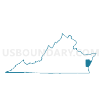
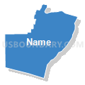
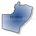
Precinct 1-1, Northampton County, Virginia
About
Outline

Summary
| Unique Area Identifier | 682213 |
| Name | Precinct 1-1 |
| County | Northampton County |
| State | Virginia |
| Area (square miles) | 308.84 |
| Land Area (square miles) | 61.47 |
| Water Area (square miles) | 247.37 |
| % of Land Area | 19.90 |
| % of Water Area | 80.10 |
| Latitude of the Internal Point | 37.16721650 |
| Longtitude of the Internal Point | -75.94180700 |
Maps


Graphs
Select a template below for downloading or customizing gragh for Precinct 1-1, Northampton County, Virginia


Neighbors
Neighoring Voting District (by Name) Neighboring Voting District on the Map
- Asbury Voting District, Hampton city, VA
- Bryan Voting District, Hampton city, VA
- Cape Henry Voting District, Virginia Beach city, VA
- Chesapeake Beach Voting District, Virginia Beach city, VA
- Eastern Voting District, Poquoson city, VA
- Harris Grove Voting District, York County, VA
- Ocean View Center Voting District, Norfolk city, VA
- Precinct 2-1, Northampton County, VA
- Precinct 3-1, Northampton County, VA
- Precinct 4-1, Northampton County, VA
Top 10 Neighboring County Subdivision (by Population) Neighboring County Subdivision on the Map
- Virginia Beach city, Virginia Beach city, VA (437,994)
- Norfolk city, Norfolk city, VA (242,803)
- Hampton city, Hampton city, VA (137,436)
- District 3, York County, VA (13,554)
- Poquoson city, Poquoson city, VA (12,150)
- District 4, Northampton County, VA (2,564)
- District 1, Northampton County, VA (2,231)
- District 3, Northampton County, VA (1,881)
- District 2, Northampton County, VA (1,523)
Top 10 Neighboring Place (by Population) Neighboring Place on the Map
- Virginia Beach city, VA (437,994)
- Norfolk city, VA (242,803)
- Hampton city, VA (137,436)
- Poquoson city, VA (12,150)
- Cheriton town, VA (487)
Top 10 Neighboring Unified School District (by Population) Neighboring Unified School District on the Map
- Virginia Beach City Public Schools, VA (437,994)
- Norfolk City Public Schools, VA (242,803)
- Hampton City Public Schools, VA (137,436)
- York County Public Schools, VA (65,464)
- Northampton County Public Schools, VA (12,389)
- Poquoson City Public Schools, VA (12,150)
Top 10 Neighboring State Legislative District Lower Chamber (by Population) Neighboring State Legislative District Lower Chamber on the Map
- State House District 83, VA (73,171)
- State House District 82, VA (70,417)
- State House District 91, VA (64,074)
- State House District 100, VA (52,095)
Top 10 Neighboring State Legislative District Upper Chamber (by Population) Neighboring State Legislative District Upper Chamber on the Map
- State Senate District 3, VA (211,723)
- State Senate District 8, VA (174,947)
- State Senate District 1, VA (170,275)
- State Senate District 6, VA (152,346)
Top 10 Neighboring 111th Congressional District (by Population) Neighboring 111th Congressional District on the Map
Top 10 Neighboring Census Tract (by Population) Neighboring Census Tract on the Map
- Census Tract 9303, Northampton County, VA (4,193)
- Census Tract 9302, Northampton County, VA (3,820)
- Census Tract 9901, Northampton County, VA (0)
- Census Tract 9901, Poquoson city, VA (0)
- Census Tract 9901, Virginia Beach city, VA (0)
- Census Tract 9901, York County, VA (0)
- Census Tract 9900, Norfolk city, VA (0)
- Census Tract 9901, Hampton city, VA (0)